Image collection »Kirchbichl«
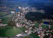
The long stretched village of Kirchbichl, one of the oldest settlements in the Unterinntal region, is situated close to the big slope of the Inn River between Kufstein and Wörgl. On the Gratenbergl, a rocky hill south of Kirchbichl, the largest settlement of the Hallstattzeit period in North Tyrol was situated. The hamlet of Kastengstatt in the region of "Haidach" was once famous for its large "hammer" (iron works), which worked 7000 m³ of iron every year from the smelting plant in Jenbach. Kichbichl was also important as a depot and the so called "Schopperstatt" (bateaux building) for the bateau shipping on the Inn River. Till recently, cement industry was very important. Today only the limestone quarries, which are well visible from great distance and the large industrial complex close to the railway station, are left.
|
|
|