Image collection »Trins«
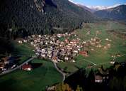
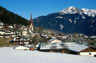
Trins is situated in the lower part of the Gschnitztal, which has its entrance near Steinach in the North Tyrolean Wipptal. The bottom of the valley is very steep from the entrance of the valley up to Trins. Southwest of Trins an impressive moraine blocks the valley, after which a late-glacial advancement was named. The flat Trinser Möser are situated further up the valley. In contrast to the gentle slopes of the shady side, the steep northern slopes are formed by limestone. Trins is a compact scattered village, which has been settled since the early Middle Ages. Buildings of historic importance are Castle Schneeburg on the Trinser Moraine and the late-gothic parish church, which dates back to the 15th century.
|
|
|