Image collection »Ultental«
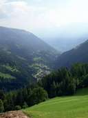
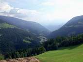
The Ultental, through which the Flaschauer River runs, has its entrance near Lana in the Meraner Basin. The entrance to the valley is characterized by the Gaulschlucht. The 40 km long valley has wooded slopes and picturesque alpine pastures. The entrance of the valley is narrow and rather monotonous. Further upstream the valley gets wider and the landscape more diverse. There are two reservoirs within the valley: Zoggler Stausee and Weißbrunnsee. In the Ultental water has played an important role from early on. There were several spas in this region. In 1414 the so called Mitterbad, with its sulphurous water rich in arsenic and iron, was first mentioned in a document. These spas were not only places where people went to have a bath, but also places of communication. People were convinced that the water could cure them from illnesses.
|
|
|