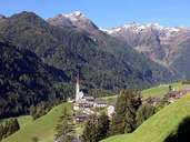
Image collection »Mühlwalder Tal«
The history of the valley is closely linked with its colonisation from the monastery Sonnberg. The entrance of the valley belongs to the Pfunderer Berge. In contrast to this the upper part of the valley belongs to the main crest of the Zillertaler Alps. Geologically the central part of the valley belongs to the inner schist layers. The entrance to the valley is formed by old gneiss. Grey-bluish marble is found in the valley. Before 1926 the valley had been divided into the administratively independent villages of Lappach and Mühlwald. In 1926 then these two villages were incorporated and form the village of Mühlwald today. In the 1960s the construction of the Neves - Stausee led to further developments. Since the 1980s tourism has become more and more important.

|
|
