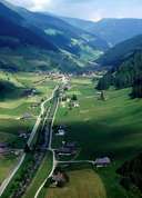
Image collection »Villgratental«
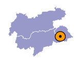
The Villgratental, located in the Deferegger Alpen, joins the Pustertal almost as a gorge at Heinfels. The eight kilometre long north-south running outer valley is only populated on the steep quartzphyllite slopes. At Außervillgraten, that hardly has an even valley floor itself, the Winkeltal, that is totally uninhabited to its uttermost outer section, branches off in a northerly direction, while the Villgratental which continues in a northwesterly direction is accompanied by individual farms and hamlets. A narrow valley floor has only been able to form at the inner part of the valley. The entire scenery of the valley is marked by the imposing Pustertaler farmhouses which are aligned with the ridge and face the valley. In Außervillgraten these can reach an altitude of 1700m. In the Winkeltal and also in the innermost part of the Villgratental a great part of the agricultural area is taken up with mountain meadows and pastures and mountain settlements. Initially the valley was used as an area of mountain pasture by farmers from the Drautal and, compared to other regions of East Tyrol, was settled relatively late in the 12th century with the establishment of the Schwaighöfe farms.

|
|
