Image collection »Pillerseetal«
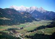
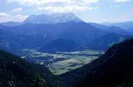
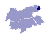
Nowadays this name refers to the Pillersee region itself and also the valley of the river Fieberbrunner Ache. This 15km long valley runs into the Leukental at St. Johann and in the east ends at the Grießenpass (976m) which is the border to the province of Salzburg. The valley is located in the transitional region between the soft rocks of the grauwacken zone and the more resistant sedimentary rocks of the Nördlichen Kalkalpen which in a northern and easterly direction make up the famous mountains of the Loferer and Leoganger Steinberge. The valley is taken up by the communities of Fieberbrunn - located on the pass plateau - and Hochfilzen. In the strictest sense, the Pillerseetal is a high-lying alpine valley and connects the valley of the Fieberbrunner Ache with the parallel-running valley in the north where the most important transport connection runs over Waidring and the Pass Strub. The scenery of the Pillerseetal, in which the two communities of St. Jakob in Haus and St. Ulrich are located, is dominated by the beautiful Pillersee which is 2kms long.

|

|
|
