Image collection »Gader«
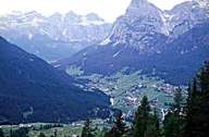
The source of the Gader lies within the Sella Mountain Range at the border between South Tyrol and the Trentino. Several other rivers coming from the Abtei Valley flow into the Gader. The Gader flows through the Gader Valley and passes several villages well-known for tourism, such as Corvara, Wengen and St. Martin i. Th. The water of the Gader River is used to generate electricity and supply snowguns with the water needed for man-made powder for skiing slopes. Just before the Gader flows into the Rienz at St. Lorenz, it runs through a narrow gorge. The Gader Valley is one of the last valleys in which Ladinic is still spoken.
|
|
Further links: Hazards Chronicle Tyrol, Weblink »Wikipedia«