Image collection »Inn«
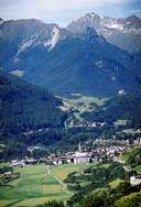
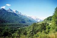
The Bezirk Inn consists of the Val Müstair, the Unterengadin and the Samnaun. The Val Müstair lies right on the boundary of the oldest nature reserve in Europe, the Schweizer Nationalpark, which covers an area of 168km2. Lü in the Val Müstair is at 1920m the highest political district in Switzerland. Samnaun is a customs-free zone because at one time it could only be reached from Austria. In the meantime a road leads to the community exclusively over Swiss territory. The former lack of direct access also led to a different language development to the remainder of German-speaking Switzerland, so that here a Bavarian-Tyrolean dialect is spoken. Scuol is the main settlement in the Unterengadin. Over 25 mineral springs have made the district a spa region with mineral and thermal springs.
|
|
|
|