Image collection »Valle dell'Adige«
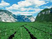
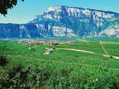
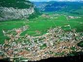
The comprensorio Valle dell' Adige is made up of four scenically different units: in the north the Piana Rotaliana (Rota-Ebene, Red Plain), in the east the Valle di Cembra, in the west the Valle dei Laghi (Valley of Lakes) and Trient including its hinterland. The Rota Ebene at the confluence of the Etsch and the Noce is an intensive and traditional wine-growing area. In the Cembra-Tal a steep-sided valley cut by the course of the Avisio, wine-growing is also an important source of income. In the Tal der Seen tourism developed relatively early and is now an important economic factor. This is also a wine and fruit-growing area, however, not to the same extent as in the Etschtal valley. The town of Trient and its hinterland have always been an economically active area. As opposed to many other alpine towns that have developed in broader parts of a valley or larger basins, the provincial capital of Trient developed on a localised narrow stretch of the Etschtal where transit routes from the side valleys met and through which the route from the Adriatic to the Brenner ran. The increase in the number of industrial companies over the last decades has led to a great increase in the number of jobs. Fruit and wine-growing remain important. Even today the areas of cultivation are being increased through the clearance of the low woodlands.
|
|
|
|