Image collection »Taufers i.M./ Tubre«
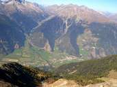
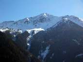
Taufers, the most western village in South Tyrol, encompasses the lower part of the Münstertal, which stretches 26 km long from the Ofen Pass (Switzerland) to the Calven (east of Glurns). The border between Italy and Switzerland, west of the central village, splits the valley in two parts: the Swiss Val Müstair and the South Tyrolean Münstertal (one third). The border runs west of the long stretched ribbon development of Taufers, which has kept its historical townscape despite numerous new developments. The village is characterized by impressive houses in the West Tyrolean architectural style, which show Taufers" former importance as a village along the medieval transit routes. The settlements of Rifair and Puntweil are also part of Taufers.
|
|
|
|
|
|