Image collection »Truden/ Trodena«
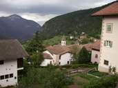
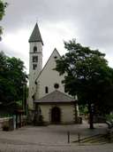
Truden, in the district of Überetsch-Unterland, had temporarily belonged to the Province of Trentino before it became part of South Tyrol again in 1949. Truden, with the villages of St. Lugan, Kaltenbrunn and Mühlen, is situated southwest of the Luganer Saddle on its eastern mountain crest following the Unterland. The scattered village of Truden is located on a southern gentle saddle with a mule track down to the Unterland. The forested gentle Trudner Horn Mountain, together with the village, is part of South Tyrol's latest nature reserve, bearing the same name like the mountain. Truden can be reached on a provincial road from Auer to the Fleimstal.
|
|
|