Image collection »Schluderns/ Sluderno«
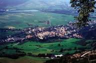
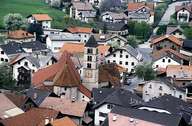
Schluderns is situated at the entrance of the Matscher Tal at the foot of the steep Sonnleiten Mountain in the upper Vinschgau Valley. Schluderns reaches from left bank of the Etsch River to the slopes up to the Litzer Peak. The Saldur Torrent runs through the compact central village. Only a few isolated houses and farms can be found in the settlements of Alt- and Neuspondinig and on the Schludernser Mountain. Schluderns is an important traffic junction between the road to the Reschen Pass (Austria) and the road to the Münstertal (Switzerland). The industrial area along the Glurnser Road attracts many commuters.
|
|
|
|
Further links: Hazards Chronicle Tyrol, Weblink »Schluderns/ Sluderno«, Weblink »Wikipedia«, tiroLexikon