Image collection »Schlanders/ Silandro«
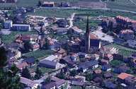
The market town of Schlanders (since 1906) stretches on both banks of the Etsch River. Schlanders encompasses the Schlandrauntal, which reaches up to the Schnalstaler Mountains in the north, the isolated farmhouses on the Nördersberg in the south and stretches along the mountain crests of the Martelltal. Schlanders, situated at the foot of the massive Gadria Landslide and the steep Sonnenberg, is the first village in the region of Untervinschgau. The neighbouring compact villages of Kortsch, Vezzan and Göflan are also part of Schlanders. Schlanders, with its rural centre and infrastructure of regional importance, is the economic centre of the Vinschgau Valley. In 1962 South Tyrol's first "Bezirksgemeinschaft" (kind of district) was founded in Schlanders.
|
|
|