Image collection »St.Pankraz/ S.Pancrazio«
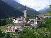
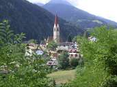
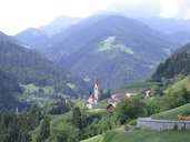
Since 1960 the Ultental, which comes from southwest and has its entrance near Lana in the central Etschtal, belongs to two villages. St. Pankraz is situated at the entrance of the valley right after the Gaul Gorge. Numerous scattered farms and hamlets, which can be reached on drives from the winding road in the valley, are located high above the steep valley, through which the Falschauer Torrent runs. Most of them can be found on the south-eastern slopes and only some are situated on the opposite side (Nörderberg). The central village of St. Pankraz with its beautiful centre is the only compact settlement with a concentration of the population. The local economy is still very much dominated by agriculture, though tourism, which has its origin in the small spas of the 19th century, has become more important.
|
|
|
|