Image collection »S.Martin de Tor/ St.Martin i.T./ S.Martino i.B.«
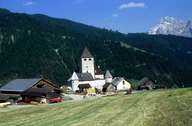
St. Martin in Thurn and Castle Thurn are situated on a terrace above the central Gadertal. St. Martin encompasses the eastern slope of the valley, the Campiller Tal (with the settlement of Campill) in the southeast, which reaches to the Peitlerkofel and Geißler Mountain Range, and the slopes of the Würzjoch Mountain, with numerous small groups of old farmhouses in Untermoi in the west. The administrative centre is to be found in the village of Pikkolein in the valley. Although both the road in the valley and the road over the Würzjoch Pass, which is highly frequented during the summer months, run through St. Martin, hardly any tourism (in contrast to the other villages in the valley) is to be found in this part of the Gadertal.
|
|