Image collection »St.Lorenzen/ S.Lorenzo d.S.«
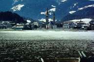
The market town of St. Lorenzen, only 3 km away from Bruneck, is situated at the confluence of the Gader and Rienz River in the west of the Brunecker Basin. St. Lorenzen, originally a Roman fortress ("Sebatum"), with its large church square, has already been a market town in the Middle Ages. St. Lorenzen is subdivided into several smaller villages and hamlets, which are located further up in the valley: while the villages of Montal and Maria Saalen are situated in the valley, the settlements of Ellen and Onach can be found on terraces above the gorge with the Gader Torrent.
|
|
|
|