Image collection »St.Leonhard i.P./ S.Leonardo i.P.«
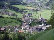
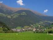
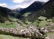
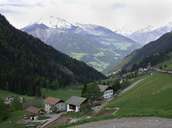
The market town of St. Leonhard lies north of the Etsch Valley in the Passeier Valley, through which the Passer River runs. The Passer River forms a 12 km long border with the neighbouring village of St. Martin. St. Leonhard stretches from the eastern slopes with the village of Schweinssteg up to the crests of the Sarntaler Alps. The central village of St. Leonhard lies at the entrance of the Walten Valley in the northeast, where the scattered settlement of Waltental is to be found. St. Leonhard has always been the centre of the entire valley, because of its geographical position at the important junction to the Jaufen Pass, which has been the passage to the Wipp Valley and to the Timmelsjoch Pass to the Ötz Valley.
|
|
|
|
|
|
|