Image collection »Salorno/ Salurn«
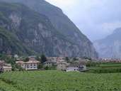
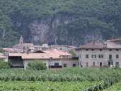
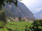
Salurn is the most southern village in South Tyrol. At Salurn the Fenn and the Geier Mountain form a gorge through which the Etsch River runs, marking the 1948 established provincial border to Trentino. Salurn encompasses the bottom of the Etsch Valley, the eastern slopes and the compact village at the foot of them. The small settlement of Buchholz lies on a terrace. The settlement of Gfrill, which partly belongs to the village of Neumarkt, lies on a saddle northeast of Buchholz. The local economy is based on fruit-growing and wine production. Salurn is one of the five communities in South Tyrol with an Italian majority.
|
|
|
|