Image collection »Partschins/ Parcines«
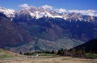
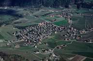
Partschins, in the district of Burggrafenamt, is situated above the rising valley of Töll at the entrance to the Vinschgau Valley. Partschins lies on either side of the Etsch River and stretches on the northern slopes up to the Texelgruppe Nature Reserve and on the southern slopes up the Marlinger Mountain with the settlement of Quadrat. The central village of Partschins - similar to the village of Rabland further upstream - is located at the foot of the Sonnenberg on the northern slopes of the Valley. The Zielbach Waterfall - with its 97 m the highest waterfall in South Tyrol - is to be found between Partschins and Rabland. Its torrents have often caused severe damage, but also revealed historic artefacts, like a Roman milestone. Partschins' economy is mainly based on tourism and fruit-growing as well as industrial and commercial businesses.
|
|
|