Image collection »Natz-Schabs/ Naz-Sciaves«
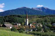
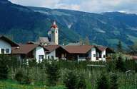
Natz-Schabs is situated on a plateau between the Eisack and Rienz River. Natz-Schabs is subdivided into several villages: the central village of Schabs on the gentle slopes, Aicha with the most northern vineyards in South Tyrol at the northern border, and the villages of Viums, Natz and Raas on the plateau. The landscape is characterized by agriculture, which has changed from the growing of corn to vegetables and later to the profitable growing of apples. These changes have been made possible after an irrigation channel was built in 1957/58, bringing water from the Lüsnertal to the plateau, on which no rivers are to be found. Additionally to the revenues from the farming sector, trading and small-sized industrial companies (especially in Schabs) and tourism are the main sources of income.
|
|
|