Image collection »Welsberg/ Monguelfo«
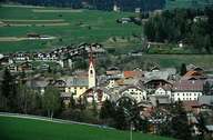
The scattered village of Welsberg stretches along the main road on either side of the Rienz River, at the entrance to the Gsieser Tal north of the upper Pustertal. Welsberg is furthermore subdivided into the villages of Taisten and Wiesen, which are situated on the southern slopes of the lower Gsieser Tal, and the hamlet of Ried on the southern slope of the valley. Agriculture has lost its former importance. Welsberg is about to become a centre for tourism and shopping. A bypass is planed, which should improve the quality of life in the centre significantly, which suffers severely from the through traffic on the Pustertaler Road.
|
|