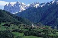
Image collection »Villnöß/ Funes«
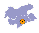
The 12 km long Villnösser Tal starts north of Klausen in the Eisacktal running in eastern direction. The Aferer Mountain with its numerous peaks and the Villnösser Geisler Mountain are situated at the back of the valley. Villnöß is subdivided into several villages, hamlets and isolated farmhouses and - except for the lower, southern part - encompasses the entire valley. Villnöß encompasses the village of Teis on a terrace on the northern slope, the central village of St. Peter in the central part of the valley, surrounding St. Valentin and St. Jakob and St. Magdalena in the upper part of the valley. A popular panorama road links the Villnösser Tal over the Würzjoch with the Ladinic Gadertal.

|

|
|
