Image collection »Völs a.S./ Fiè a.S.«
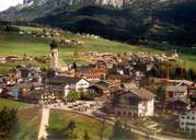
Völs is subdivided into several settlements and stretches from the steep gorge-like Eisacktal with the village of Blumau, over the terraces in the south (Tierser Tal) with the scattered settlement of Völser Aicha up to the large, ice-age terrace with the main settlements. Untervöls, the expanding central village with its compact centre, is situated on a hill on the terrace. West of Untervöls the large village of Obervöls, with its beautiful farmhouses, is to be found at the foot of the massive Schlern Mountain Range. Völs gains most of its revenues from tourism, which has started in the 19th century when the bourgeois of Bozen discovered Völs as a summer resort. Since the construction of the road (1953) from Blumau up to the villages on the terrace, the number of tourists has constantly increased.
|
|
|