Image collection »Toblach/ Dobbiaco«
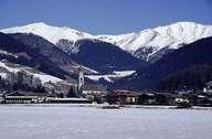
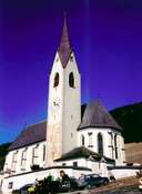
Toblach is situated on the "Toblacher Feld" (above 1200 m), the highest point of the Pustertal. This is Europe's watershed: the Rienz River runs into the Adriatic Sea, whereas the Drau River runs to the Black Sea. The scattered village of (Alt-)Toblach, with the striking onion-shaped church steeple, is located on the fan of the Sylvester Torrent. The village is situated at an important traffic junction. The "Strada d'Alemagna", coming from the Pustertal, follows the long Höhlensteintal in the south. In former times this traffic route connected the economic centres of Venice and Augsburg. The new village of Neu-Toblach, which is connected with Alt-Toblach, started to develop when the railroad and the train station were built. The Sylvestertal is also part of the village.
|
|
|
|
|
|
|