Tirol Atlas Archive

tiroLexikon

^UP

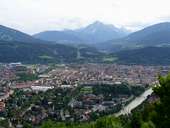
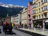
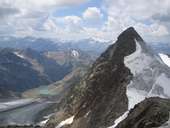
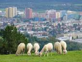
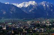
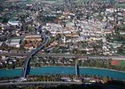
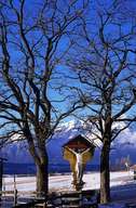
Galleria fotografica »Innsbruck«

Tirol Atlas image No.°11014
Innsbruck con Serles (2.718m)
Tirol Atlas image No.°10958
Via Maria-Theresien-Straße, Innsbruck
Tirol Atlas image No.°11025
Zuckerhütl (3.507m), Alpi Stubaier Alpen
Tirol Atlas image No.°10535
Pecore - Olympisches Dorf, Innsbruck
Tirol Atlas image No.°11231
Vordere Brandjochspitze (2.559m), Innsbruck
Tirol Atlas image No.°10551
Mariahilfstraße, Innsbruck
Tirol Atlas image No.°5734
Innsbruck, il centro storico
Tirol Atlas image No.°10563
Centro Storico, Innsbruck
Tirol Atlas image No.°10568
Centro Storico, Innsbruck
Tirol Atlas image No.°10576
Centro Storico, Innsbruck
Tirol Atlas image No.°10548
Tetto d'oro, Innsbruck
Tirol Atlas image No.°10538
Tetto d'oro, Innsbruck
Tirol Atlas image No.°10552
Ottoburg, Innsbruck
Tirol Atlas image No.°10554
Monumento "Vater und Sohn", Innsbruck
Tirol Atlas image No.°10556
Ristorante Goldener Adler, Innsbruck
Tirol Atlas image No.°10566
Mercatino di Natale, Innsbruck
Tirol Atlas image No.°10561
Duomo St. Jakob, Innsbruck
Tirol Atlas image No.°10572
Duomo St. Jakob, Innsbruck
Tirol Atlas image No.°10549
Palazzo Palais - Innsbruck
Tirol Atlas image No.°10571
Innsbruck - Inverno 2005/2006
Tirol Atlas image No.°10550
Olympisches Dorf, zona industriale
Tirol Atlas image No.°7335
Castel Ambras
Tirol Atlas image No.°11126
Ponte Europabrücke
Tirol Atlas image No.°10541
Trampolino - Monte Isel
Tirol Atlas image No.°10544
Innsbruck, Mühlau, Arzl, Rum,Thaur, Hall e Absam
Tirol Atlas image No.°11703
it:Innsbruck, mit östl. Mittelgebirge
Tirol Atlas image No.°10555
Vecchio Funicolare Seegrube, Innsbruck
Tirol Atlas image No.°10559
Habicht (3277 m), Kirchdach Spitze (2796 m)
Tirol Atlas image No.°10534
Obernbergtal
Tirol Atlas image No.°10564
iHochalm e Schwarze Wand
Tirol Atlas image No.°9176
Pfriemeswand (destra) e Spitzmandl (sinistra)
Tirol Atlas image No.°10562
Höttinger Alpeggio
Tirol Atlas image No.°10543
Bergeralm - Untere Wipptal
Tirol Atlas image No.°10542
Zona Sciistica - Bergeralm bei Steinach
Tirol Atlas image No.°2739
Vista sulla Stubaital
Tirol Atlas image No.°10536
Hafelekar Spitze (2334 m)
Tirol Atlas image No.°10546
Halfpipe - Zona Sciistica Seegrube
Tirol Atlas image No.°10539
Bodensteiner Alpeggio
Tirol Atlas image No.°10553
Festa di Ringraziamento per il Raccolto
Tirol Atlas image No.°10557
Festa di Ringraziamento per il Raccolto, Arzl
Tirol Atlas image No.°4991
Hall in Tirol
Tirol Atlas image No.°5708
Hall in Tirol
Tirol Atlas image No.°3489
Patsch
it:Übersichtskarte
Carta topografica
Altri collegamenti: tiroLexikon