Image collection »Weerberg«
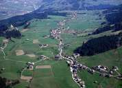
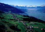
Most of Weerberg is situated on an ice age terrace, formed by gravel, 300 m above the southern side of the Unterinntal. Weerberg is subdivided into Außer-, Mitter- and Innerweerberg. The village expands like a ribbon along the foot of the more than 2500 m high Gilferts Mountain. Weerberg, a popular residential area, is affected by housing sprawl. This is clearly shown in Hausstatt, a settlement on a slope at up to 1255 m above sea level, where two opposing architectural styles are to be found side by side: traditional wooden farmhouses and contemporary architecture.
|
|
|
|
|
|