Image collection »Vomp«
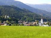
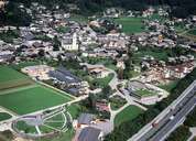
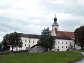
Vomp in the Unterinntal stretches from the Inn River, across the mountain crest of the Karwendel Mountain Range to the German border. The old centre with the Benedictine Abbey of Fiecht from the late-baroque period is situated at the foot of the mountain. The rural village of Vomperberg, which is located on a terrace 200 m above the bottom of the valley, houses the religious community of the Knights of the Grail (founder: Oskar Ernst Bernhard a.k.a. Abd-ru-shin). The village of Hinterriss within the Karwendel nature reserve with its Alpine settlement of Eng with the "Große Ahornboden" (area with old mountain maples), which can only be reached from Bavaria, are other attractions of Vomp. Vomp is economically closely linked with the neighbouring district capital of Schwaz. In the last years Schwaz and Vomp have grown together with new housing and industrial areas between the highway and the Inn River
|
|
|
|