Image collection »Terfens«
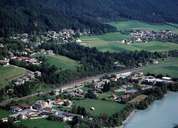
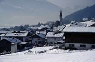
Terfens, consisting of several settlements, stretches along the northern bank of the Inn River in the Unterinntal. The old village of Terfens, which is situated on a narrow terrace above the Inn River, together with the scattered villages of Schlögelsbach and Umlberg on another terrace 200 m above Terfens, is still characterized by the farming sector. Besides agriculture, small- and medium-sized companies (several joineries and a plant producing long-distance heating from burning wood) are the main sources of income for Terfens. These companies are located in the new settlements of Neu-Terfens and Vomperbach, which have grown into large residential areas.
|
|
|