Image collection »Gerlosberg«
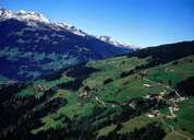
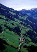
The southern slopes at the entrance of the Gerlos Valley belong to Gerlosberg. Gerlosberg is still very much characterized by agriculture. Small hamlets and detached farmhouses are situated in far distance to each other on the steep slopes. Because of the distance and steep slopes road access is very difficult. Some of the farmhouses still can only be reached by a material funicular from the other side of the valley. Because of the exposed slopes facing south, farmhouses can be found up to 1277 m (Hundsbichler). A forest belt divides farm land from alpine pasture land. During winter these alpine pasture lands are part of the skiing area of "Zillertal Arena".

|

|
|
