Image collection »Bruck a.Z.«
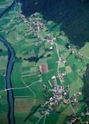
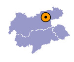
Bruck is situated east of the Ziller River near the entrance of the Zillertal. The two original hamlets of Bruck and Imming (both have grown into larger settlements) are situated on the slope of the Brucker Mountain, on which impressive isolated detached farmhouses are to be found in big clearings. Agriculture still plays a significant role in Bruck, which is best shown by the great number of hereditary home steads. In Bruck and Imming small commercial enterprises and businesses related to tourism are to be found. A road over the Kerschbaumer Saddle links Bruck with the close Alpbachtal.

|
|
