Image collection »Brandberg«
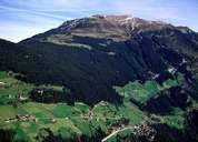
Brandberg encompasses nearly the entire catchment area of the Zillergrund. Most of Brandberg's population lives on the sunny slopes 200 m above the Ziller River at the entrance of the valley. The Zillergrund and its valleys (Boden, Sunder, Hundskehle, Zillergründl) with their post-glacial landscape are used as seasonal alpine pastures. The landscape is furthermore characterized by the Zillergründl Reservoir with its power station Häusling. In contrast to the mass tourism to be found in nearby Mayrhofen, Brandberg puts a lot of effort into ecologically sustainable tourism, which is reflected in the membership of various organisations such as the network "Allianz in den Alpen".

|
|
