Image collection »Weißenbach a.L.«
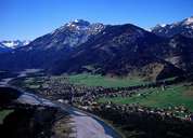
Weißenbach is a sparsely settled, but long stretched village along the Lechtaler Road. Because of the narrow road through the village, traffic goes on a bypass around Weißenbach. The proximity to nearby Reutte (10 km) has led to an expansion of the village and the founding of some small industrial and commercial enterprises. Weißenbach was founded at the starting point of the medieval Salz Road over the Gaicht Mountain Pass to the Tannheimertal and to Lake Constance. The hamlet of Gaicht, which belongs to Weißenbach, is situated at the beginning of this high valley. A so called "Wetterstadel" was built in Gaicht to protect the salt from Hall, when weather conditions made it impossible to ascend the pass.
|
|