Image collection »Wängle«
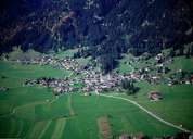
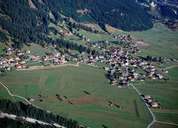
Wängle is situated east of Reutte at the foot of the Tannheimer Mountains. One assumes that Wängle and Breitenwang belong to the oldest settlements within the Außerfern region, possibly dating back to the 10th century. The scattered village of Wängle with its surrounding hamlets has become a big agglomeration, leading to a change in the structure of the settlement. In former times agriculture and seasonal work were the main sources of income in the village. Today people commute to the industrial area around Reutte and Breitenwang. Wängle was the parish for the villages on the left side of the Lechtal, similar to Breitenwang, which was responsible for the villages on the right side.
|
|
|