Image collection »Steeg«
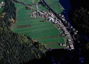
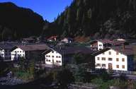
Steeg is the last village near the end of the narrow, upper part of the Lechtal, with the impressive Pimig Peak in the southwest. From Steeg, a meanwhile upgraded road, which often was closed due to avalanches in the past, goes to Warth in Vorarlberg (Bregenzerwald and Lech am Arlberg). Steeg encompasses the long stretched settlement along the road, the small village Hägerau with the church, the hamlets on the terraced slope including Ellenbogen and the hamlets of Gehren and Lechleiten high up the mountain. The last two belong to the diocese of Feldkirch, due to its proximity to Warth. A road into the Kaisertal in the south connects Steeg with Kaisers, the village at the highest altitude within the district.
|
|
|