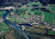
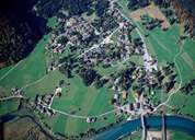
Image collection »Pflach«
The long stretched village of Pflach, 2 km north of Reutte, has become a dormitory town for Reutte and Breitenwang due to the building of new housing estates within the last decades. The population has grown significantly since the incorporation of the two hamlets of Ober- and Unterletzen on the left bank of the Lech River. In the Middle Ages Pflach belonged to Breitenwang. Today the two villages still form one parish. The "Hüttenmühlkapelle" Chapel from 1515 with its gothic winged altar reflects the former important iron mining area around Säuling. The newly established innovation centre tries to re-establish the formerly successful metal works.
|
|
|