Image collection »Nesselwängle«
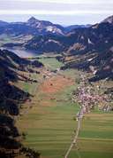
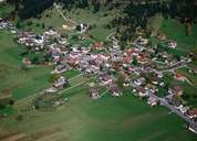
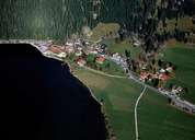
Nesselwängle is situated at the entrance of the Tannheimertal, on the foot of the impressive Tannheimer Mountains, which are popular among climbers. Nesselwängle is subdivided into three settlement units: the village stretching along the road, which got its present appearance in the second half of the 19th century, after two destructive fires, secondly the hamlet of Rauth (a.k.a. "Kleinmeran"), which is situated on the steep slopes facing the Lechtal and thirdly the village of Haller at the picturesque Lake Halden. The houses with their shingled facade exposed to the weather, and the living rooms facing east to the sun are typical for the Tannheimertal. The road through Nesselwängle was built on the fans of several torrents. In former times the village gained wealth through the transportation of salt from Hall to the region around Lake Constance. Even though Nesselwängle lives from tourism, many people still have to commute.
|
|
|
|