Image collection »Kaisers«
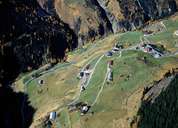
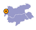
The small village of Kaisers is situated in the last inhabited section in a valley south of the Lechtal. Kaisers consists of the hamlet Kienberg, situated 4,5 km away from Steeg in the Lechtal, and the settlement of Kaisers (above 1500 m) with its isolated farmhouses on the steep mountain slopes. With the construction of avalanche barriers protecting the road, one has managed to stop the migration of the people in Kaisers. Kaisers was first settled by settlers from the district of Landeck, to which it belonged politically till 1947. In the 19th century Kaisers became a popular starting point for hiking tours in the surrounding mountains. That was the reason why the parsonage was also the "Gasthaus zum guten Tropfen" guesthouse till World War II.

|
|
