Image collection »Biberwier«
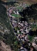
Biberwier, situated on the southern edge of the Lermooser Basin, belongs to the local tourist region. The long stretched village extends in the narrow gap between mountain slopes and the depositional area of the big Fernpass Land Slide. By building the Leermooser tunnel 20 years ago, the traffic over the Fern Pass no longer has to go through the village. At the northern boundary of Biberwier parts of the Roman Via Claudia Augusta Road have been found recently. In the Leermooser Moos a Roman road and a Roman settlement were excavated. From the Middle Ages till 1921 the mining of lead, zinc and other ores made Biberwier the most important mining community in the Außerfern region. The popular lakes of Blindsee, Weißensee and Mittersee can be found south of Biberwier.
|
|
|
|
|
|