Image collection »Berwang«
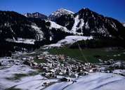
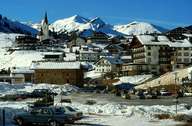
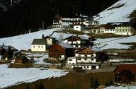
The scattered village of Berwang lies on an altitude of 1300 m above sea level on the declining hilltop, which links the Berwanger Tal with the Rotlechtal. The other parts of the village, such as Kleinstockach and Bichlbächle, are situated below 1300 m. Those two hamlets can be reached from the centre of the Berwanger Tal and are characterized by mountain farming. The hamlets of Brand, Mitteregg and the larger settlement of Rinnen are situated on the steep and sunny slopes of the Rotlechtal. Since the 1920's winter tourism plays a significant role in Rinnen, and pushed back the formerly significant farming sector and in this way changed the settlement and economy of Berwang completely. Due to this shift in the local economy the once important mountain pasture lands are no longer cultivated.
|
|
|
|