Image collection »Strassen«
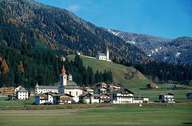
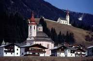
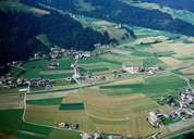
Strassen stretches at the bottom and on the large fan of the Thurn Torrent, which plunges down from the Heisinger Höhe to Abfaltersbach in the east. By damming water in the west, the fan led to a boggy plain. All settlements are located on the sunny side of the valley, north of the Drau River. Strassen is characterized by two churches: the so called "Lower" church in Strassen, the centre of the village along the Pustertal Road and the "Upper" parish church towering a hill in the north. Strassen is subdivided into nine settlements, most of them are hamlets. In Tassenbach, at the eastern end of the village, a road runs through the Tyrolean Gailtal into the Lesachtal.
|
|
|
|