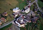
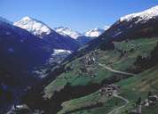
Image collection »St.Veit i.D.«
The alpine village of St. Veit is situated on the sunny slopes in the centre of the Defereggental, which runs in east-west direction. The hamlets of Zotten, Bruggen and Feld stretch along the road into the valley. The rest of the village, consisting the hamlets and isolated farmhouses and the centre of St. Veit with its striking parish church, are situated on steep slopes at an altitude between 1400 and 1600 m above sea level. Many hamlets, such as Gsaritzen, Gritzen and Görtschach, have Slavic names. Due to the fact that many people cannot gain their living from agriculture anymore they have to commute to St. Jakob and Lienz.
|
|
|