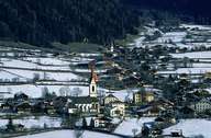
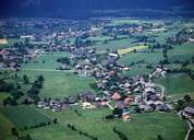
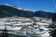
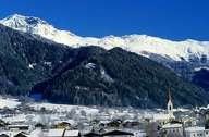
Image collection »Oberlienz«
The main settlements of Oberlienz is situated on the fan of the Schleinitz Torrent, one of the largest in the Tyrol, on the sunny side of the valley. The fan forms the natural border to the Lienzer Basin. The formerly administratively independent villages of Oberlienz and Oberdrum, which were characterized by the so called "Paarhof" farmhouses, now form a settlement unit with agglomerative clusters around the two former centres. By building the bypass at the edge of the fan, one managed to ban most of the traffic from the village. The rural village of Glanz is situated 200 m above the bottom of the valley on the opposite side and forms the third settlement unit of Oberlienz.
|
|
|
|
|
|