Image collection »Gaimberg«
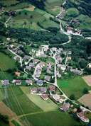
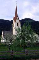
Gaimberg, north of Lienz, is situated on the gentle slopes of the Zettersfeld Mountain. The expanding village consists of rural settlements, hamlets and detached farmhouses in the regional architectural style. Not much of the formerly important fields and orchards at a high altitude can still be found. Grafendorf, a small scattered village with the community centre and the parish church is the centre of Gaimberg. Even though the Wartschensiedlung Settlement belongs politically to Gaimberg, it has grown so close to the nearby village of Nußdorf-Debant that children are sent to school there and even belong to the same parish. The station at the bottom of the Zettersfeld ski lift, as well as most of the skiing area bearing the same name, belongs to Gaimberg. The former farming community has become a popular residential area within the last decades.
|
|
|