Image collection »Tösens«
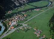
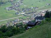
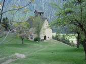
Tösens is situated in a narrow part of the Oberinntal. Together with Tobadill, it is one of the poorest villages in the district of Landeck. Tösens encompasses the long stretched village and some hamlets on the bottom of the valley as well as on the slope. In the 15th century varlets mined for minerals (silver, ...) in the Patzer- and Berglertal around the Arzkopf Mountain. The mines belonged to the highest in the Alps and had temporarily to be closed due to advancing glacier. In 1910 they were finally closed due to a lack of economic profitability. Tösens is famous for the Georgskirche church, a small Roman church above the village, and the so called "Römerbrücke", a medieval bridge over the Inn River.
|
|
|
|