Image collection »Pians«
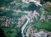
West of Pians the Rosanna River (coming from the Stanzertal) and the Trisanna River (coming from the Patznaun) meet and form the Trisanna River, which runs through a gorge towards Landeck. The compact settlement of Pians is situated on a slope in the first small gap within this gorge. Before the construction of the Arlberg Schnellstraße Road, Pians had suffered from the traffig running through the village. Several other settlements are situated on the slopes of the Parseier Peak (with 3036 m the highest summit of the Lechtaler Alps in the north). The area around Pians, with its mild climate has already been settled in pre-Roman times. Pians got its name from the Latin word for footbridge "pedaneus".
|
|