Image collection »Kauns«
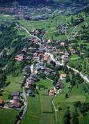
Kauns is situated at the confluence of the Kaunertal and the upper - Inntal. Kauns stretches from the bottom of the Kaunertal, over the sunny slopes due north to the neighbouring village of Kaunerberg and the archeologically significant area around the Piller Saddle, which attracts many tourists every year. Kauns, situated on a terrace 100 m above the valley , offers some historic sites, such as Castle Bernegg. Kauns, on the foot of the Kaunergrat Mountain, is situated in a beautiful surrounding. Kauns is part of the "Naturpark Kaunergrat" Nature Reserve.
|
|
|