Image collection »Reith i.A.«
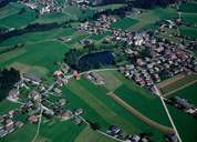
Reith im Alpbachtal with its 2740 hectares stretches from the bottom of the Inntal in the west till the boundary of Alpbach with the settlements of Hygna and Kolber on the orographic left side and the settlement of Naschberg on the orographic right side. Reith, which was first mentioned in a document in 976, has its centre 2 km south on a wide terrace, on which massive layers of gravel were deposited during the last interglacial period. The 1,5 hectare large Reither Lake is popular among swimmers. Besides agriculture, tourism has become an important source of income for Reith im Alpbachtal.
|
|
|
|
|
|