Image collection »Münster«
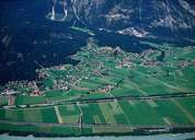
Münster is situated on a gentle slope on the left side of the Inn River. Münster encompasses the central settlement of Münster and the hamlet of Asten with castles of Lichtenwerth and Lipperheide on the other side of the river. Excavations show that Münster has already been settled in Roman times. The parish church of Maria Himmelfahrt, surrounded by legends, got its baroque look in the 18th century. In the last years the population and the number of houses in Münster have increased. Tourism and agriculture are the most important sources of income in Münster.
|
|