Image collection »Westendorf«
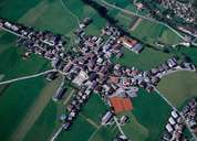
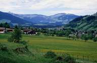
Westendorf is situated away from the main road on a sunny terrace above the Brixental at the foot of the Choralpe Mountain. Most of Westendorf is forested or farming land. The scattered village was first mentioned in a document in 1320. Westendorf, which is characterized by tourism, is subdivided into villages, hamlets, recent housing developments, a mixed development of houses and commercial businesses along the road and railway at the bottom of the valley as well as scattered isolated farmhouses. The 15 km long Windau Valley in the south was already a mining area in the Middle Ages. Today it is a popular destination for daytrips. Due to several lifts, summer and winter tourism have become the main source of income.
|
|
|