Image collection »Kirchberg i.T.«
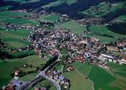
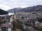
Kirchberg in Tirol (837 m) is situated at the watershed between the Brixental and the Leukental. Kirchberg's economy is based on summer and winter tourism, which is reflected by the number of second homes and the number of over-night stays, which is often higher than the one in Kitzbühel. The village is subdivided into several villages, hamlets and scattered settlements on the slopes. Documents dating back as early as the 14th century show that Kirchberg was once an important mining village in the Kitzbühler Alps. The quality of life in Kirchberg has improved since most of the traffic goes on the 1997 opened bypass.
|
|
|
|
|
|